Articles in ‘Geography of Britain’

Record rainfall in the Lake District

November 23rd, 2009

The Guardian’s Country Diary has a vivid description of the recent torrential rain in the Lake District, which resulted in the catastrophic flooding of the Cockermouth area. Here’s an extract:

Sheets of precipitation ran off the waterlogged ground and into the becks and rivers, which stampeded downhill causing landslides and destroying bridges and collapsing embankments.  . . . few Lakeland valleys escaped. Waterfalls cascaded down crags, sweeping scree on to roads so that rocks litter the tarmac, some big enough to have smashed through drystone walls and leave gouges in the fellsides in their wake.

About 25 cm of rain fell in 24 hours, making it the wettest day ever recorded in Cumbria. This quantity is the equivalent of the rainfall usually experienced in the Southeast of England over 5-6 months. Newcastle University researchers have found that rainstorms in the UK have doubled in intensity over the last 40 years, due in part to increased water evaporation from warmer seas.

A geological history of Britain

October 23rd, 2009

Gad Cliff to St Alban's Head

This week’s In Our Time, the ever erudite BBC Radio 4 series chaired by Melvyn Bragg, looks at the geological formation of Britain. The panel of experts discuss how Britain came to be where it is now, charting its separation of North America and Europe to the carving out of the English Channel, and also what is still not understand about the rocks beneath us. Available on demand hopefully forever here.

Around six hundred million years ago, the island that we now call Britain was in two parts, far to the south of the Equator. Scotland – and north-western Ireland – were part of a continent (Laurentia) that also included what is now North America. To the south-east, near the Antarctic Circle, meanwhile, you would have found Southern Ireland, England and Wales. They formed a mini-continent (Avalonia) with what is now Newfoundland. Over the course of hundreds of millions of years, as they inched their way north, the two parts came together, first as part of a vast unitary continent (Pangaea), later as a promontory on the edge of Europe, and eventually, as sea levels rose, as an island.

In the photo the so-called Jurassic Coast along the coast of southern England from Wikipedia by Jim Chapmion.

How did the Needles get their name?

August 7th, 2009

The western tip of the Isle of Wight peters out in a series of three jagged rocks known as the Needles.  You might think they owe their name to their sharp edges but it turns out there used to be a fourth, needle-shaped, rock called Lot’s wife, as shown in Isaac Taylor’s map of Hampshire published in 1759.  Read the rest of this entry

Britain’s smallest island

July 28th, 2009

Britain’s smallest island lies off the south west coast at the western tip of the Scilly Isles.  Bishop Rock is also classed in the Guinness Book of Records as the smallest built-on island in the world.  In fact, the only building is a lighthouse, as there isn’t room for anything else. To the west of Bishop Rock, there’s no more land till the American coast, so it bears the full brunt of Atlantic gales.  The lighthouse was built with great difficulty – the first one was washed away in 1850 before it could be used.  An enormous wave once snatched away the 550lb fog bell.  The island has not been inhabited since 1992 when the lighthouse became fully automated and the last keepers left.
The lighthouse features in the BBC’s Seven Man Made Wonders

The geographical centre of Great Britain

July 24th, 2009

Peat bog near the exact centre of Great Britain

According to the Ordnance Survey, the geographical centre of Great Britain (factoring in its 401 associated islands) lies at unmarked point surrounded by peat bog on Brennand Farm, about four miles north-west of Dunsop Bridge. This BBC page goes in search of it armed with a GPS.

The Northumberland town Haltwhistle also claims to be the centre.

The lowest land point in Britain

July 24th, 2009

Holme Fen, Cambridgeshire

The village of of Holme Fen, specifically Holme Posts as depicted above, is probably the lowest land point in England at nearly 3 metres (9.8 ft) below sea level. Wikipedia

See also

UK’s lowest spot getting lower
“Conservationists have raised concerns that the lowest land spot in the UK is sinking.Holme Fen, a national nature reserve near Peterborough in Cambridgeshire, has sunk by about four metres since draining work began in the 1850s, leaving it about 2.75 m below sea level. ” BBC

Holme Fen is a rare surviving relic of the vast fenlands that once covered the countryside in parts of East Anglia. Listen to BBC documentary about Holme Fen here.

The gnomes of Wastwater

July 23rd, 2009

In the mysterious depths of Scotland’s lochs lurk legendary and elusive monsters. At the bottom of England’s deepest lake there are gnomes.  Read the rest of this entry

Deepest lake in Britain

July 23rd, 2009

Photo: A. Kurata

The deepest lake in the UK is Loch Morar in the Scottish Highlands, which reaches a depth of 309 metres (754 ft). This steep-sided glacial lake – 19 km long –has its own monster, just like Loch Ness, which the locals call Morag.  Read the rest of this entry

The Corryvreckan whirlpool

July 18th, 2009

Remarkably the third largest whirlpool in the world, the Corryvreckan whirlpool, lies in Scottish waters. It is located in the narrow strait between the islands of Jura and Scarba. The names comes from the Gaelic, Coirebhreacain meaning “cauldron of the speckled seas. Read the rest of this entry

Remembering the Great Storm of 1987

July 13th, 2009

Anyone out of the country that week in October came back to find an altered landscape.  An estimated 15 million trees had been toppled, mainly in southern England, which bore the brunt of the hurricane-force winds.  The north of Britain is used to ferocious winds, but the south hadn’t experienced anything like it for nearly 300 years.  The result was a large population of very tall, old trees that had never been tested by such severe weather conditions. Read the rest of this entry

Abandoned villages in the UK

July 10th, 2009

This site on Abandoned Communities in Britain is fascinating and poignant. Since the Middle Ages thousands of towns, villages, and other human communities in Great Britain have been abandoned. Often the settlement was abandoned because of economic and social changes, but sometimes also due to the forces of nature. Many tell a tragic story. The web “commemorates all abandoned communities” through text, photos, paintings and poetry.

The biggest / highest waterfalls in Britain

July 1st, 2009
Eas a Chual Aluinn from Loch Beag

Read the rest of this entry

Loch Coruisk

June 8th, 2009

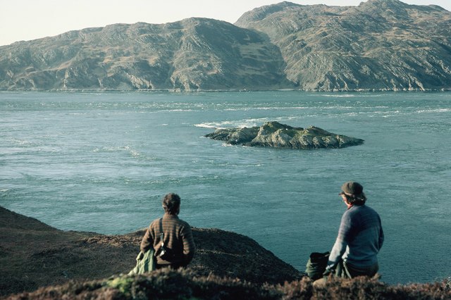
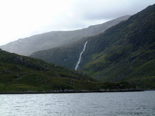
Loch Coruisk in the Isle of Skye is one of the most spectacular and isolated places in the British Isles.  The head of this freshwater loch is surrounded on three sides by the imposing volcanic Black Cuillin while the southern end runs into a small rivulet, which then discharges into a sea loch, Loch Scavaig. Coruisk is an Anglicisation  of the Scottish Gaelic, Coire Uisg meaning “Cauldron of Waters”. As with much of the Highlands, once it would have been thickly wooded. Deforestation has left it all the bleaker.

Robert Macfarlane visited Loch Coruisk  in his tour of Britain’s remotest parts, The Wild Places. He describes it as the greatest example in Britain of what he calls “sanctuaries”: hidden valleys with all the lure of lost worlds.

Sir Walter Scott visited the loch in 1814 and described it vividly:

“Rarely human eye has known
A scene so stern as that dread lake,
With its dark ledge of barren stone…”

Lord Tennyson was somewhat more descriptive:

“Loch Coruisk, said to be the wildest scene in the Highlands, I failed in seeing. After a fatiguing expedition over the roughest ground on a wet day we arrived at the banks of the loch, and made acquaintance with the extremest tiptoes of the hills, all else being thick wool-white fog

The loch has been painted by many painters including Sidney Richard Percy (1821-1886) who painted the above picture, William Daniell (1769-1837), J.M.W. Turner (1775-1851), and Alexander Francis Lydon (1836-1917). Turner almost fell to his death while painting this view of the Black Cuillin from a crag high up the valley.

The foreground figures help establish the scale of this awe inspiring view over the remote Loch Coruisk. The Cuillin Mountains soar above the loch like gigantic waves. Read National Galleries of Scotland

The loch is accessible by boat from Elgol, or, most usually, a 7-8 mile hike from Sligachan.

See also

  • Loch Coruisk - Wikipedia
  • Misty Isle Boat Trips. We are a family-run business running boat trips from Elgol on the Isle of Skye to the famous Loch Coruisk in the heart of the Cuillin Hills.
  • Skye - Loch Coruisk Cruises
  • Review of The Wild Places in the Guardian “In certain predictable ways, his early travels provide him with “the real” that he wants. On the island of Ynys Enlli, off the westernmost tip of the Lleyn Peninsula, he identifies with the contemplative and austere connectedness of the original peregrini - the monks and other devout solitaries who settled there. In Coruisk, the loch-filled valley on the southwest coast of the Isle of Skye, he encounters “a silence that reached backwards to the Ice Age” (similar sorts of time-travel occur in later chapters as well). Making “an ice-bound traverse” of Rannoch Moor, trekking through the Black Wood east of Rannoch, teetering on cliffs that define the north coast of Scotland and contemplating the peatbogs (the “Flows”) nearby, he is at once taken out of himself and connected with the original need for his journeys. They are all places that put human achievement in the perspective of eternity and generate a sense of the primitive that is salutary and bracing.”

Zoological and natural hazards in Britain

June 8th, 2009

Volcanic eruptions, lightning strikes, lizard bites and hornet stings caused some of the more unusual injuries listed by the Department of Health (DoH).

From the Guardian here :
Accidents cost the NHS about £1bn a year. The most common cause of injury was falling, which led to 119,203 admissions to casualty.

Thousands suffered attacks from a wide variety of animals. These included 451 people stung by hornets, 46 bitten by venomous snakes and lizards, 24 bitten by rats, 15 injured in contact with a marine mammal, two people bitten by centipedes and one attacked by an alligator. But dogs accounted for most injuries with 3,508 people suffering bites.

Hundreds more fell victims to natural hazards, with 54 people struck by lightning, 37 victims of “volcanic eruption” (sic), 25 injured in “cataclysmic storms”, 12 suffered from avalanches and seven were victims of earthquakes. A further 107 were exposed to “unspecified forces of nature”.

Adder bites in the UK

From the NHS (Plus lots of information on symptoms, causes, diagnosis, treatment and prevention of adder bites)

  • Each year, approximately 100 cases of adder bites are reported in the UK. Most bites occur between February and October, with the number of bites peaking during the summer months. Note: I was bitten by an adder in Norfolk in 1972 when I was seven, though it did not inject much venom).
  • Since records began in 1876 there have only been 14 reported deaths caused by adder bites, with the last death  a 5-year-old child in 1975.
  • In addition to the adder, it is estimated that there are 75 species of exotic venomous snakes held in the UK, both legally and illegally, by private snake collectors and enthusiasts. These snakes are thought to be responsible for between five to six cases of snake bites in the UK each year. Most cases involve the snake’s owner

Statistically you have more chance of being killed by a wasp than dying at the teeth of Britain’s only venomous snake. The Independent

Worst natural disaster in British history

June 8th, 2009

According to experts a tsunami in the Bristol Channel could have caused the deaths of as many as 2,000 people in one of Britain’s greatest natural disasters.

Map

Shading shows area affected by the 1607 disaster

For centuries, it has been thought that the great flood of January 1607 was caused by high tides and severe storms. It is estimated that 200 square miles of land in south Wales and south west England were covered by water. Eyewitness accounts of the disaster, published in six different pamphlets of the time, told of “huge and mighty hills of water” advancing at a speed “faster than a greyhound can run” and only receding 10 days later. Professor Simon Haslett, from Bath Spa University College, said: “There is an overall theme running through the pamphlets of a destructive event, very violent, disastrous, on a scale that is unprecedented.” Australian geologist Ted Bryant, from the University of Wollongong, agreed: “The waves are described as mountainous - that’s a description of a tsunami.” Read all (BBC)

Bristol Channel floods, 1607 (Wikipedia)

On 30 January 1607 the Bristol Channel floods resulted in the drowning of an estimated 2,000 or more people, with houses and villages swept away, an estimated 200 square miles (518 km2) of farmland inundated and livestock destroyed, wrecking the local economy along the coasts of the Bristol Channel. The devastation was particularly bad on the Welsh side from Laugharne in Carmarthenshire to above Chepstow on the English border. Cardiff was the most badly affected town. The coasts of Devon and the Somerset Levels as far inland as Glastonbury Tor, 14 miles (23 km) from the coast, were also affected.

There remain plaques up to 8 feet (2 m) above sea level to show how high the waters rose on the sides of the surviving churches. It was commemorated in a contemporary pamphlet God’s warning to the people of England by the great overflowing of the waters or floods.

“Gods Warning to his people of England.”. The British Library. Fascinating contemporary account

“Many there were which fled into the tops of high trees, and there were inforced to abide some three daies, some more, and some lesse, without any victuals at all, there suffring much colde besides many other calamities, and some of them in such sort, that through overmuch hunger and cold, some of them fell down againe out of the Trees, and so were like to perish for want of succour. Othersome, safe in the tops of high Trees as aforesaid, beholding their wives, children and servants, swimming (remediles of all succour) in the Waters. “

Other UK tsunamis include a 70ft high wave that hit Scotland 7,000 years ago, following a massive landslip in Norway.